Underwater Still and Video Cameras
Peter Lawton’s research aims to document the presence and abundance of species on the seabed. He sees if species presence can be linked to particular features such as seabed type or near-seabed current strength. He then uses this to predict where we might find particular species. He uses many different camera and video systems: some operated by him while SCUBA diving, others operated remotely from the surface.
Dive DeeperTechnology Interview
How do you survey shallow waters?
For depths shallower than about 20 metres we can survey the seabed by SCUBA diving. I can make notes on what I see—I can collect, measure, and count marine species. I also carry underwater cameras to take a photographic record of what species I find in particular locations. While diving I can closely investigate the seabed habitat, turning over rocks to discover small species hiding under them. I also get a sense of how the habitat type changes over the course of a dive. Diving does need access to a well-trained team of divers. Conditions in the Bay of Fundy can sometimes be hazardous. We’re often limited in where we can dive by poor visibility or strong currents.
How about areas that are too deep to SCUBA dive?
Beyond SCUBA diving depths, we use camera systems to look at the seabed. We control them remotely from boats on the surface. During my career I’ve designed several different seabed video camera systems. We can operate these down to depths of 100 to 150 metres. Many areas in the Bay of Fundy and off Nova Scotia are within this depth range.
And what about even deeper waters?
Beyond those depths and down to 3000 metres I have to use systems provided by other specialist ocean technology groups. These include Canada’s ROPOS (Remotely Operated Platform for Ocean Sciences) system. The Canadian Scientific Submersible Facility operates this Remotely Operated Vehicle (ROV). It’s big! — around three metres long and weighing over 3000 kilograms. It has two high-definition video cameras and a high-resolution still camera. We use two robotic arms to take samples or operate tools. These tools range from suction samplers that vacuum up specimens to underwater chainsaws to cut rock.
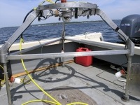
Urchin 2 Drop camera system used between 2006-7. (Photo: Fisheries and Oceans Canada)
Do you need a lot of people to help with your surveys?
ROVs such as ROPOS often have dedicated operation teams of four to eight ocean technologists. Piloting an ROV is a skilled job and takes a lot of training. The complicated sampling moves the pilots can do amaze me. These include picking up small glass sponges out of the seabed. Imagine picking a single daisy up out of a lawn. Now think of doing that from over a kilometre away viewing the scene on a TV screen and moving a robotic arm to take hold of the flower.
Do you have to use big boats?
ROVs are large, so large oceanographic research vessels carry them. Teams of university and government researchers work together on the survey missions. There may be between 10 and 30 scientists on board each research cruise. The projects often provide the opportunity and data for students to pursue advanced degrees in marine science. Someone has to provide coordination among the teams and to make decisions with the ship’s captain on the daily survey operations. We call this role the “Chief Scientist.” I’ve been Chief Scientist for five of the nine offshore missions I’ve taken part in since 2005.
What do you have to think about when designing a survey?
Taking direct observations underwater or capturing images from camera systems is just part of my project work. Scientists have to think about how to design their surveys. They consider the area of seabed that will make up a single “sample” and how to distribute those samples across different seabed types. Two general approaches are transect surveys and quadrat sampling. Transect surveys cover a continuous band of the seabed. For example, a diver may swim along a marked line, searching the seabed within an area 1 metre wide by 100 metres long. Quadrat sampling takes samples from many small, independent areas of the seabed. For example, a camera system that drops to the seabed and takes a photo of an area 1 metre wide by 1 metre long.
The next challenge is dealing with the large number of individual images or hours of continuous video that the surveys captured. For some projects that may include over 1000 images or over 100 hours of video. To be efficient in the analysis stage, the scientist may decide to analyze only a subset of images or video. This reduces the time it will take someone to identify and count species on the images but still obtains representative counts.
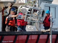
Coastal drop camera system, in operation since 2014. (Photo: Fisheries and Oceans Canada)
How has technology changed during your career?
Using SCUBA diving and underwater cameras to survey seabed habitats is not a new pursuit. Back in the 1960s and 1970s, research was underway at the St. Andrews Biological Station using these techniques. From the 1980s to today I’ve continued to use these approaches, bringing in new technologies as they’ve become available. At the start of my own research, the main technologies available for underwater use were film-based cameras, standard definition video cameras, and analog (tape-based) video recorders. Starting in the 2000s, there has been a shift to the use of digital systems both for still image cameras and video cameras. The resolution of images has increased substantially, with the common TV standard in the 2010s being known as high definition. Most recently a new technology, ultra-high definition, has been introduced. I’ve used this in my work since 2015.
Do you have to use expensive cameras?
Camera systems have become much more available—even your mobile phone is likely to have a much more capable camera than many of the cameras I had access to in the past. You can now buy waterproof “action” camera systems and even remote underwater camera systems. Many recreational water sport enthusiasts use these. While these represent great technological advances, scientists still need to use professional-level systems. Especially where they need to get lots of information from the images or if they have to work in deep water.
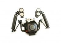
Blackmagic 4K video camera, setup for SCUBA. (Photo: Fisheries and Oceans Canada)
How do you track where your images were taken?
As well as getting high-quality images, scientists need to know the exact location and depth from which they’ve taken them. On your phone you can see your location on a live map. The phone can pick up signals from four or more satellites and calculate how far away it is from them. It then uses this to work out its position. We call this the Global Positioning System (GPS). Marine scientists can use GPS to get boat positions, but it doesn't work under the sea as the satellite signals can't penetrate water. Under water scientists can use acoustic positioning. This works in a similar way to GPS but uses sound, sent out by transducers, rather than satellite signals.
How do you think this field will develop in the future?
Over the 30 years I've been doing marine research, I’ve seen dramatic improvements in technology. This has included cameras, image storage systems, and position tracking technology. Such technologies are now used throughout society—think again of the capabilities of your mobile phone. Over the next decade there will be further advances. Immersive 360-degree imagery will let us remotely experience the seafloor. We’ll use robots (autonomous underwater vehicles) to explore. We’ll be able to use artificial intelligence to help analyze the images we collect. I hope there will also be new capabilities in SCUBA diving and other manned underwater systems. I still believe it is important to put scientists underwater to discover the underwater world through their own eyes.


