Multibeam Sonar
Ian Church uses multibeam sonar to map the seafloor. From his research vessel, he sends a fan of sound pulses into the water. These bounce off the seabed and back to the survey vessel. We know the speed that sound travels through water so we can calculate the seabed depth from the time it takes for us to hear the echo. Ian combines millions of sonar readings to make detailed maps.
Dive DeeperTechnology Interview
What technology do you use for your work?
We use a variety of sophisticated technology in our work, but our primary tool is the multibeam sonar. Sonar stands for SOund NAvigation and Ranging. It’s based on the principle that sound can travel long distances in water. We send a sound pulse into the water and wait to hear the echo from the seabed (this is where the term “echo sounding” comes from). We know the speed of sound through water (about 1500 metres per second) and how long it took for us to hear the echo. From this we can calculate the distance to the seafloor. That gives us a depth measurement.
On top of that depth measurement, we also need to know where we are, so we use GPS satellites to determine our location on earth. With unique algorithms and technology, we can define our position anywhere on earth from GPS with an accuracy of about 10 centimetres.

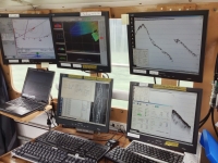
A bank of computers on board the research vessel captures and records the sonar data. (Photo: Ian Church/University of New Brunswick)
How does multibeam sonar work?
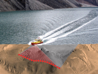
Multibeam sonar is an extension of the simple sonar system that I described above. The critical difference is that instead of listening to an echo that is coming from directly below us, we listen for echoes coming from hundreds of different directions across the seafloor. These echoes form what looks like a fan of sound beams coming back to the ship. Listening to echoes coming from different directions allows us to map the seafloor more efficiently. We can cover a larger area with each pass of the vessel, and we can measure small details on the seabed.

As the boat passes over, it scans the seabed with a fan of sonar beams. Beams bounce off the seabed and return to the vessel where the echo is recorded. (Photo: Ian Church/University of New Brunswick)
Is this a new technology? What did people do before its invention when they wanted to map the seabed?
Sonar has been around for about 100 years, and the technology behind commercial multibeam sonar is about 40 years old. While that might sound like old technology, it’s actually quite new when you consider that people have been mapping the oceans for over 1000 years. Before the invention of sonar, people took depth measurements using a device known as a sounding-line or lead-line. The sounding-line consisted of a lead weight attached to a long cord with depth markings at specific intervals.
How did a sounding line work?
People threw the lead weight over the side of the ship and lowered it to the bottom of the ocean. Once it hit bottom, they could read the depth from the markings on the cord, and then they hauled it up on board the ship again. This was quite easy in shallow water but was much more difficult and time-consuming in deep water. Sometimes the lead weight on the line had a hollow base with a sticky material to bring back a sample of the sediment on the bottom (shells, sand, etc.). People making nautical charts (sea maps) could then show the type of seabed. This helped with finding good fishing grounds and places to anchor. Charts still in use around the world, including in Canadian waters, use soundings and sea bed types recorded from a sounding-line.
What vessels do you work from? Do you have to live on board?
We work from vessels of all shapes and sizes. These range from autonomous, remote-controlled boats only a metre long to large ocean-going ships over 100 metres in length. When I was mapping unexplored areas of the Canadian Arctic, we used Coast Guard icebreakers equipped with multibeam sonar. Sometimes you get to stay on board the vessel and sometimes you are at home every night. It generally depends on how remote the survey area is. With small boats, you often only work during the day. On large vessels, like the Coast Guard icebreakers, you work in shifts because the ship operates 24 hours a day. In these situations, you stay on board with other scientists, technicians, and personnel for anywhere between a few days and a few weeks.

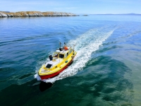
The UNB Ocean mapping group often work from the CSL Heron. She is 10 metres long and equipped with a unique suite of acoustic survey instruments. (Photo: Ian Church/University of New Brunswick)
What interesting places has your work taken you to?
Ocean mapping is needed everywhere there’s water, and that takes you to some incredible places around the world. You will often get to explore amazing areas that few other people get to visit. I’ve been lucky enough to travel all around the globe doing ocean mapping, including the east and west coasts of Canada, the North West Passage and other parts of the Canadian Arctic, Hawaii, California, Florida, the Gulf of Mexico, the Mediterranean Sea, Australia, Singapore, and the Northern Marianas Islands in the Western Pacific.


