Peter Lawton,
Benthic Ecologist
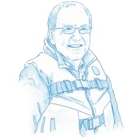
Peter Lawton is a Research Scientist with Fisheries and Oceans Canada. He studies and maps the species that live on the seabed. He uses SCUBA diving and surface-deployed camera systems to study shallow coastal waters. He also participates on offshore missions to explore areas in the deep-sea that have never been surveyed before.
Dive DeeperMarine Career Interview
What do you do?
I’m a Research Scientist with Fisheries and Oceans Canada based at the St. Andrews Biological Station in St. Andrews, New Brunswick. I've worked here for all my 35-year career, apart from a three-year period of work at a university in New York State. I study the marine environments of the Bay of Fundy and Gulf of Maine.
What did you work on in your early career?
During the 1990s and early 2000s, I worked on lobsters and crabs, two of the species that are fished commercially in this region. I researched their biology and ecology. I also looked at where they occurred and if human ocean uses, including fishing and aquaculture, were impacting populations. I used this information to provide advice to fishermen and fishery managers on how they could manage stocks. I had to present my advice and respond to questions from industry and other stakeholders on the science behind the advice.
What is your focus now?
From the mid-2000s to today, my research and science advisory work have evolved to looking at distributions of various species in the oceans. I look at how physical features of the ocean seabed influence where we find particular species. This is an area of research we call marine habitat mapping.
Canada is currently trying to protect the marine biodiversity found within its oceans. One of the options for doing this is creating Marine Protected Areas. These will protect areas that have special features, such as populations of rare or important species. They will also protect examples of different habitat types. My habitat mapping provides information to help develop these.
Why is mapping seabed habitats important?
On land it is easier to choose protected areas. The work of undertaking scientific assessment is difficult but at least land areas are possible to get to. We can see both the individual trees and know where the forests start and end. Technology has helped with this. Where we once used photographic surveys from planes, we now have flying drones. We also have much higher resolution satellite images.
When it comes to the ocean, it’s only been in the last 10 to 20 years that technology has developed enough to gain a similar map view of seabed habitats. Scientists carry out surveys from ships that send out acoustic signals, or sonar. These signals travel through the water column, bounce off the seabed, and back up to the vessel. These “soundings” provide both the depth and some sense of the type of seabed material—a soft mud or hard rock—at specific locations. We can now produce seabed maps that look similar to land maps.
Once we know about the depth, shape, and composition of the seabed, we can start to look at where we find marine species. Do they occur on sandy or muddy habitats? On flat rock or on steep walls? This is where the type of work that I do contributes. From what we see while SCUBA diving, or by reviewing photos and video of the seabed, we can confirm the presence of species in specific locations. We can then use this information to predict where else we might find them.
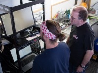
Peter Lawton reviews live seabed images onboard the Viola M. Davidson. (Photo: Fisheries and Oceans Canada)
What does your typical day involve?
That depends on when you ask me! From May to October each year it’s quite likely I would be preparing for or actually heading out to conduct surveys in coastal or offshore areas.
Come and see me in the winter months, and my day will be quite different. It’s more focused on desk work such as data analysis and writing up research reports. I'll often tinker with new computer or camera equipment that I plan to use in the next summer's field research projects.
What does your coastal research involve?
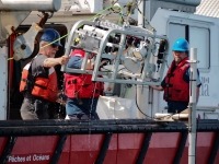
For coastal studies I might be operating our custom dive survey vessel and carrying out dives with colleagues. On another day I may be out on our local Coast Guard research vessel doing seabed surveys at depths beyond those we can safely dive in. On those days my field team and I operate a custom near-seabed video survey system. It has quite a lot of sophisticated electronics! We often find ourselves trouble-shooting various connection problems and other equipment issues. On those days I often work as a computer or electronics technician rather than a scientist.
Do you also work in deeper waters?
Yes, I also take part in longer research missions exploring deep sea systems off the Canadian and US coasts. These projects are large, collaborative missions that take a year or more to coordinate and often last for two to three weeks. On these missions I’ve been able to visit places that have never been surveyed before, such as canyons off the New England coast. These projects are also exciting because I get the chance to work with university research teams, and help in mentoring the next generation of marine scientists.
What do you enjoy most about your job?
Through my career I’ve been able to use a variety of computer, photographic, and video systems to investigate the underwater world. Often I’ve been one of the first scientists in the department to use a particular new technology. This brings with it some problems. “It’s great to be at the leading edge but it’s also easy to fall off,” was a comment a computer support person once made on a camera issue I had.
I’ve also been able to work from the shoreline to deep waters over three kilometres deep! I’ve seen for myself the complexity and beauty of the underwater world. I've also seen the impacts of some of our uses of the sea, such as coastal aquaculture, ocean disposal activities, and fishing.
I also enjoy working with the next generation of scientists. I’m involved in several large research networks in Canada and abroad. Through these I’ve been able to mentor young scientists as they develop new innovative approaches.
What is an important qualification for your work? / How did you get your position?
I did my initial academic training in the UK. I developed an interest in fisheries science. The research Canadian scientists were conducting impressed me. I realized I needed a postgraduate degree to work in other countries so I started to study for my PhD. I then wrote to researchers in Canada about possibilities to take up a postdoctoral fellowship. This is a short appointment of one to three years. You work in a university or government research lab to build up research skills. I did fellowships in Canada and in the US before taking up my permanent job with Fisheries and Oceans Canada.
I learned to dive during my first period of work in St. Andrews. Diving became a central part of my research programs. One local dive study I’ve been doing has just completed its 30th consecutive year of sampling.
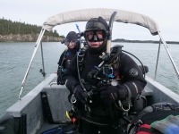
Peter Lawton prepares to dive. (Photo: Fisheries and Oceans Canada)
Any advice for people wanting to work in this field?
Depending on the level of your academic interests and aspirations, obtaining both a first degree and then a second degree or diploma is a good start.
Practical skills and being able to troubleshoot are also important. With our advanced technologies today, it’s easy to expect technology to work for us when we want it, and then to throw up our hands when it doesn’t. We can’t always undertake full repairs on complicated equipment, but often the cause of the problem is a very simple issue and fix.
Primarily though, I’d say perseverance is the thing that will bring you to the point you want to get to. Through my career I put a lot of effort into planning the next steps. I contacted people and discussed potential ways to work with them on problems of mutual interest.
What inspired you to work in marine biology?
At high school in the UK, I particularly enjoyed biology and geography. In both cases we were able to go out on week-long residential field trips, part of which involved undertaking our own research project. On a marine biology field trip, I studied the shell form of a local marine species, called a limpet. I looked at how their shells vary in relation to the types of environment they live in. The shells are conical, and both the angle of the cone and its thickness vary depending on how exposed these animals are to wave action. This is an aspect of science called bio-mechanics. I found this topic very interesting. I studied it further in my PhD research into how crabs and lobsters feed on shelled prey. Of course, the other aspect of that early effort was trying to understand how the environment affected how animals manage to survive, and how the availability of different types of habitat affects their distribution. That still underpins the research that I carry out.


